MenciSoftware APS
APS A powerful and widely tested photogrammetry software suite for processing massive and accurate UAV data.
APS caters to users of all skill levels with multiple interactive steps up to a fully automated process.
It runs on your desktop computer or laptop and processes small and medium-sized aerial images into 2D maps and 3D models with centimeter accuracy.
APS processes ground imagery from various types of drones, but it must include GPS data (optionally also IMU data). Images should be acquired in strips with a standard overlap (horizontal and vertical) of 70-80%.
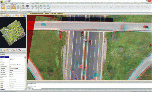
APS has three expansion modules: StereoCAD (for stereoscopic inspection and 3D CAD plotting), TerrainTools (a professional DEM editor and viewer), and APSCheck (fast during field flight inspection).
APS Key Features


-
4-channel image management
-
Update DSM-generated memory
-
"Optical Flow Matching" Bundling Strategy
-
"Import from PhotoScan" tool
-
New DSM Generation Algorithm
-
New DSM "Fill Holes" Algorithm
-
True-OrthoPhoto create
-
"GPU Explainer Match" Bundling Strategy Speed and Quality Improvement
-
"CPU Explainer Match" Bundling Strategy Speed and Quality Improvement
-
Lever arm support
-
"GPU Explainer Match" and "CPU Explainer Match" can use Yaw, Pitch, and Roll (or Omega, Phi, and Kappa) angles.
-
GPU Explainer Match" Bundling Strategy
-
Get images from "CPU Explainer Match" Bundle Strategy Drone/UAV (TIF, JPG)
-
Import images without IMU angle data
-
The camera passport has an automatic extraction function.
-
Extract GPS data from EXIF
-
Get GPS data represented in a variety of formats
-
Equipped with selectable cameras
-
Multi-sensor RGB and NIR project support
-
Five bundle algorithms with editable parameters
-
Get GCP, collimation, and visualization
-
Radio Metric Color Balancing
-
Automatic DSM creation
-
Create Contour
-
Automatically create/view Textured Mesh
-
Automatic filtering of DTM ground in preset scenarios
-
Creating and Editing Seams
-
Setting and Importing Tiles
-
Creating ortho-mosaic
-
ortho-mosaic calibration editor
-
Create and view 3D point clouds
-
All common CAD editing commands
-
Powerful multi-threaded and GPU support
-
Launch batch from command line
-
Export Custom Band Composition
-
Multilingual support
-
Available on Windows Vista/7/8/8.1 64-bit